Skip to content
SRP Albanian Engineering - Konsulence Inxhinierike
  • Home
  • About Us
  • Sectors
    • Water Supply
    • Sewerage
    • Road Infrastructure
    • Structural/Buildings
    • Bridge Engineering
    • Topographic Survey
    • Information Technology
  • Portfolio
  • Jobs
  • News
  • Contact
  • Language: English
    • Shqip Shqip
    • English English
Parku Kombëtar të Butrintit
  • Share on Facebook
  • Share on Twitter
  • Share on LinkedIn
  • August 19, 2021
  • Portfolio, Topographic Survey
  • dronesurvey, Photogrametry, Kadastrale, UNESCO
  • Print
Project Title: Cadastral Topographic Survey Service for the “Initial Property Registration of Sub- Zones A3” located within the Butrint National Park territory
Company

SRP ALBANIAN ENGINEERING

Project Location Project Budget SRPAE Share Involved Staff
Ksamil, Albania - 100 % 6
Employer Name Fund Source Start-End Date Partner
AADF (Albanian-American Development Foundation) AADF (Albanian-American Development Foundation) 06/2021 - 07/2021
Project Description

Under the Cultural Tourism and Ecotourism program, AADF has funded a significant number of projects in the Butrint National Park with the aim of transforming it into a sustainable development model in cultural heritage sector in Albania. The engagement of the AADF in preserving, protecting and promoting the UNESCO World Heritage Butrint National Park (BNP), as one of the main archaeological parks in the country, began along with the establishment of the Foundation. Since 2010, AADF has contributed to installation of cameras, tourism infrastructure and signs, the environmental rehabilitation of the new road, the installation of the firefighting system, and the development of the integrated management plan. These projects have had considerable impact on the improvement and increase of revenues at the site. In this context, it is important that cultural heritage areas, known as Butrint Sub-Zones A3, be registered as state property in the Saranda Cadastre.

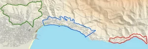
The aim of this project is the Cadastral Registration as state property, part of Butrint national park  entitled as the sub-zones A3.

Project Objectives:

  • Realization of topographic surveys with photogrammetric methods
  • Carrying out cadastral surveys
  • Calculation of properties affected by subzones A3
  • Final definition of boundaries of subzones A3 and formalization of boundary points

Phase I: Cadastral Survey: Data collection, analysis, and interpretation. Realization of topographic and photogrammetric measurements of the project areas. Implementation of GIS System based on data collection and analyses.

Phase II: Formalization of boundaries on the ground: Placement of physical markers on the ground to realize the contouring of properties

Services Provided by the consultand

SRP Albanian Engineering is responsible for carrying out all project tasks.
Cadastral survey with photogrammetry
Recognition of properties affected by property nationalization
Recognition and definition of subzone A3 boundary.

SRP Network

  • SRP Schneider + Partner – Head Office
  • SRP Schneider + Partner – International
  • SRP – Albanian Branch

SRP AE

  • About Us
  • Contact Us
  • Work With Us

Latest News

Realistic 3d Model for the #Butrinti Archeological Park
Energy efficiency rehabilitation programme student city 1 - Tirana
Energy efficiency rehabilitation programme student city 1 &#…

Kontakti Me Ne

SRP Albanian Engineering
Asocuar me SRP SCHNEIDER & PARTNER
Rr. Tom Plezha, Pll.Klensi, Shk.4, App.2, Yzberisht, Tirane, Shqiperi
+355 48 272 528
© 2023 SRP Albanian Engineering - Konsulence Inxhinierike | Dizenjuar nga Aktiv 21