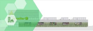
Nën programin e Turizmit Kulturor dhe Ekoturizmit, AADF ka financuar një numër të konsiderueshëm projektesh në Parkun Kombëtar të Butrintit me qëllim shndërrimin e tij në model të qëndrueshëm të zhvillimit në trashëgiminë kulturore. Angazhimi i AADF-së në ruajtjen, mbrojtjen dhe promovimin e Parkut Kombëtar të Butrintit (PKB), si një prej parqeve arkeologjike kryesore të vendit, është i hershëm. Që në vitin 2010, AADF ka kontribuar me instalimin e kamerave, infrastrukturës dhe sinjalistikës turistike, rehabilitimin mjedisor të rrugës së re, instalimin e sistemit të mbrojtjes kundër zjarrit dhe përgatitjen e planit të menaxhimit të integruar. Këto projekte kanë pasur një ndikim të rëndësishëm në përmirësimin dhe rritjen e të ardhurave të Butrintit. Në këtë kuadër, është e rëndësishme që zonat pasuri kulturore, të njohura si Nënzonat A3 të Butrintit, të regjistrohen si pronë shtetërore në Kadastrën e Sarandës
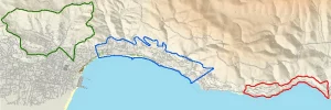
Qëllimi i këtij projekti është regjistrimi kadastral si prone shteterore te nenzonave A3, pjese e parkut kombetar te Butrintit
Objektivat
- Realizimin e rilevimeve topografike me metoda fotogrametrike
- Realizimin e rilevimeve kadastrale
- Njehesimin e pronave te prekura nga nenzonat A3
- Percaktimi perfundimtar I kufijve te nenzonave A3 dhe formalizimi i pikave kufi
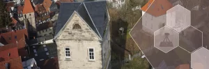
Faza I: Rilevimi Kadastral: Grumbullimi i te dhenave, analizimi dhe interpretimi i tyre. Realizimi i matjeve topografike dhe fotogrametrike te zonave te projektit.
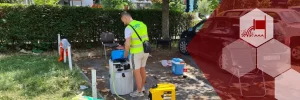
Faza II: Formalizimi i kufive ne terren: Vendosja e piketave fizikisht ne terren per te realizuar konturimin e pronave